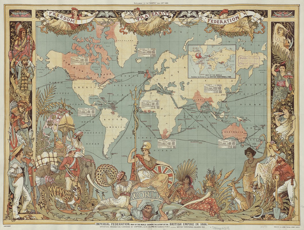
Imperial Federation, Map of the World Showing the Extent of the British Empire in 1886
A hand-painted replica of Walter Crane’s masterpiece Imperial Federation, Map of the World Showing the Extent of the British Empire in 1886, meticulously crafted by professional artists to capture the true essence of the original. Each piece is created with museum-quality canvas and rare mineral pigments, carefully painted by experienced artists with delicate brushstrokes and rich, layered colors to perfectly recreate the texture of the original artwork. Unlike machine-printed reproductions, this hand-painted version brings the painting to life, infused with the artist’s emotions and skill in every stroke. Whether for personal collection or home decoration, it instantly elevates the artistic atmosphere of any space.
"Imperial Federation, Map of the World Showing the Extent of the British Empire in 1886" is a notable work by the English artist and illustrator Walter Crane. Created in 1886, this map is a vivid representation of the British Empire at its zenith, showcasing the vast territories under British control during the late 19th century. Walter Crane, known for his contributions to the Arts and Crafts Movement, utilized his artistic skills to produce a map that is both informative and visually striking.
The map was commissioned by the Imperial Federation League, an organization that advocated for the unification of the British Empire into a single federated entity. The League believed that such a federation would strengthen the bonds between the colonies and the mother country, ensuring mutual defense and economic prosperity. Crane's map was intended to promote this vision by illustrating the global reach and power of the British Empire.
In the map, the British territories are highlighted in red, a common cartographic convention of the time. This visual technique immediately draws the viewer's attention to the vastness of the Empire, which spanned continents and included significant portions of Africa, Asia, the Americas, and Oceania. The map not only serves as a geographical representation but also as a piece of propaganda, emphasizing the unity and strength of the British Empire.
Crane's artistic style is evident in the decorative elements surrounding the map. The borders are adorned with intricate designs and allegorical figures that symbolize various aspects of the Empire, such as commerce, industry, and navigation. These embellishments reflect Crane's background in decorative arts and his ability to merge aesthetic beauty with political messaging.
The map also includes insets that provide additional information about the British Empire. These insets feature statistical data, such as population figures and economic output, which underscore the Empire's global dominance. By combining visual appeal with factual data, Crane's map effectively communicates the grandeur and significance of the British Empire to its contemporary audience.
Walter Crane's "Imperial Federation, Map of the World Showing the Extent of the British Empire in 1886" is more than just a cartographic document; it is a historical artifact that captures the imperialist sentiment of the late 19th century. The map reflects the ambitions and ideologies of the time, serving as a reminder of the British Empire's impact on world history.
Today, the map is studied not only for its artistic merit but also for its historical significance. It provides insight into the mindset of the period and the ways in which art and propaganda were used to shape public perception and political discourse. As a piece of historical cartography, it remains a valuable resource for understanding the complexities of the British Empire and its legacy.